|
About
Teesta River |
|
The
Teesta River or Tista is said to be the lifeline of the Indian
state of Sikkim, flowing for almost the entire length of the
state and carving out verdant Himalayan temperate and tropical
river valleys. The river then forms the border between Sikkim
and West Bengal before joining the Brahmaputra as a tributary
in Bangladesh. The total length of the river is 309 km (192
mi). It drains an area of 12,540 km². Before a large part of
this was situated in Nepal. But after the Sugauli Treaty it
was granted to British India.
The Teesta River originates in the Himalayas and flows through
the Indian States of Sikkim and West Bengal before entering
Bangladesh, where it flows into the Brahmaputra. Flowing
through the length of Sikkim, the Teesta River is considered
to be the lifeline of the state. The Teesta valley in Sikkim
is rich in biodiversity, and the river provides livelihoods
for the residents along its entire length of 393 km (245
miles).
Proposed dams
India has proposed a series of dams within the Teesta river
system that should produce some 50,000 MW of electricity
within the next 10 years. With some of the largest sediment
loads, the creation of a reservoir will lead to an increased
pressure on an active fault area. There are concerns that the
building of these dams may lead to river-induced seismicity.
Despite such worries the construction of the dams had started.
Links are suspected between the dam construction and the
deadly 2011 earthquake in Sikkim. |
|
| |
|
Geography of Teesta River |
|
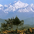
Through its course, the Teesta river has carved out ravines and
gorges in Sikkim meandering through the hills with the hill
station of Kalimpong lying just off the river. Multicolored
vegetation can be seen along this route. At lower heights,
tropical deciduous trees and shrubs cover the surrounding hills;
alpine vegetation is seen at the upper altitudes. The river is
flanked by white sand which is used by the construction industry
in the region. Large boulders in and around the waters make it
perfect for rafting enthusiasts.
Between Rangpo town and the railway bridge (popularly called
Lohapul or iron bridge) on it as it enters the plains at Sevoke,
the Teesta flows with a very strong current, ideal for white
river rafting. Towns like Teesta Bazaar and Melli have
facilities for group rafting. Though the river looks safe, the
underlying current is very strong. During the monsoons, this
humble river expands its banks; both in size and turbulence.
Landslides in this region often dam up parts of the river in
this season. |
|
| |
|
Climate and Tectonics of Teesta River |
|
The
Teesta river has preserved good imprints of climatic and
tectonics along its valleys and catchments. The major
alluviation and incision events could be attributed to the
factors associated with climatic processes such as strengthening
or weakening of monsoonal precipitation and related fluvial
discharge. Tectonic activity affects sediment fluxes and is
responsible for the insetting of younger terraces/fanlobes into
the older terraces/fanlobes. During seismic events, landslide
activity along the slopes of river valleys influences sediment
delivery into the valleys, causing the effects of tectonics to
be intricately coupled with that of climate
The terraces and floodplains, valley-side slopes and landslide
slopes, alluvial cones of different generations, kettle-shaped
depressions, sickle-shaped ranges, leveled plains, undulating
plains and deeply dissected valleys, and glacial and periglacial
deposits are some of the geomorphological features observed in
the Teesta river basin in Sikkim. Three prominent knick points
have been observed along the Teesta river profiles which
correspond to the zones of tectonic discontinuities, the
important ones being the MCT and MBT (e.g. Seeber and Gornitz,
1983). Results of recent studies indicate that the southern part
of the frontal wedge near the foothill zone is tectonically
active along with the formation of NKT, SKT and MFT structures
within the sub-Himalaya in the Teesta basin. |
|
|
|
|
Teesta River Course |
|
The Teesta River originates from the Pahunri (or Teesta
Kangse) glacier above 7,068 m (23,189 ft), and flows
southward through gorges and rapids in the Sikkim
Himalaya. It is fed by streams arising in the Thangu,
Yumthang and Donkia-La ranges. The river then flows past
the town of Rangpo where the Rangpo River joins, and where
it forms the border between Sikkim and West Bengal up to
Teesta Bazaar. Just before the Teesta Bridge, where the
roads from Kalimpong and Darjeeling join, the river is met
by its main tributary, the Rangeet River. At this point,
it changes course southwards flowing into West Bengal. The
river hits the plains at Sevoke, 22 km (14 mi) north of
Siliguri, where it extends by the Coronation Bridge
linking the northeast states to the rest of India. The
river then courses its way to Jalpaiguri and then to
Rangpur District of Bangladesh, before finally merging
with the Brahmaputra River at Fulchori. |
|
|
|
|
Changes in Course of Rivers |
|
Great
changes have taken place in the course of some of the rivers in
Bengal and the adjacent areas, during the period since 1500 CE.
Although positive evidence is lacking, similar changes can be
assumed in the remoter past. The Teesta River is one of the
rivers that has changed over the years.
The Teesta earlier ran south from Jalpaiguri in three channels,
namely, the Karatoya to the east, the Punarbhaba in the west and
the Atrai in the centre. The three channels possibly gave the
name to the river as Trisrota "possessed of three streams" which
has been shortened and corrupted to Teesta. Of these three, the
Punarbhaba joined the Mahananda. The Atrai passing through a
huge marshy area known as Chalan Beel joined the Karatoya and
the united stream joined the Padma(Ganges) near Jafarganj. In
the critical floods of 1787, the Teesta river forsook its old
channel and rushing south-east it joined the Brahmaputra. James
Rennell made a survey between 1764 and 1777 and his maps are one
of the earliest authentic maps of Bengal in existence. In these
maps Teesta is shown as flowing through North Bengal in several
branches - Punarbhaba, Atrai, Karatoya, etc. All these streams
combined lower down with the Mahananda, now the westernmost
river in North Bengal, and taking the name of Hoorsagar finally
discharged into the Ganges at Jafarganj, near modern Goalundo.
The Hoorsagar river is still in existence, being the combined
outfall of the Baral, a spill channel of the Ganges, the Atrai,
the Jamuna or Jamuneswari (not the main Jamuna through which the
Brahmaputra now flows), and the Karatoya, but instead of falling
into the Ganges, it falls into the main Jamuna, a few miles
above its confluence with the Padma at Goalundo. |
|
|
|
|
|
|
|
|
|