|
|
|
Kannur |
| |
| |
|
Information about Kannur
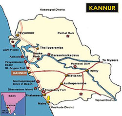
Kannur, also known as the Cannanore is bordered by the
Western Ghats in the east, Wayanad in the south,
Lakshadweep Islands in the west and Kasaragod in the
north. Kannur covers an area of 2997 square km. The
Kannur district is bounded by a wealth of natural
beauty. This district has also contributed in the
cultural, religious, political and industrial heritage
of Kerala. Kannur has also been the cradle of colourful
folk art and music of Kerala. |
 |
|
|
|
|
Tourist
Attractions in Kannur
The various tourist attractions in Kannur are Payyambalam
Beach, St. Angelo Fort, Valapattanam, Meenkunnu Beach,
Parassinikadavu, Snake Park, Muzhapilangad Beach, Gundert
Bungalow, Trichambaram Temple, Thalasseri Fort, Madayi Para,
Thodeekulam Siva Temple, Pazhassi Dam, Ezhimala, Pythal Mala
and Sree Ramaswami Temple.
More....
|
|
|
|
 |
|
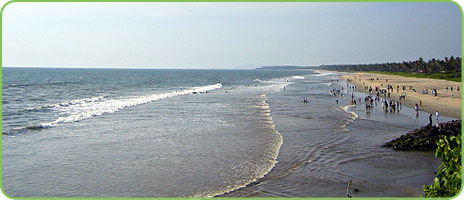
Payyambalam
Beach |
|
Festivals in
Kannur
Theyyam festival and Kottiyoor festival are the main festivals
which are celebrated in Kannur. The Theyyam festival is
celebrated from the month of December to May. Kottiyoor
festival is celebrated in the month of May and June in the
Kottiyoor. A Siva Temple is located here on the banks of the
Bavali River. Thousands of devotees attend the festival for 27
days.
How to reach Kannur
By Air:
The nearest airport for Kannur is located at Kozhikode, which
is about 93 kms.
By Rail:
Kannur is one of the important railway stations of Southern
Railway.
By Road:
Kannur is well connected by road. An excellent road transport
system connects Kannur to all the major towns of South India
like Mangalore, Bangalore, Kochi etc. |
|
|