|
|
|
Meghalaya |
|
|
Information about Meghalaya
Meghalaya literally means abode of the Clouds. Meghalaya is a
small state in north-eastern India. It is a hilly strip in the
eastern part of the country about 300 km long and 100 km wide.
It is bounded in the south and southwest by Bangladesh and
other sides by Assam. Meghalaya is situated just south of the
Brahmaputra river and is a compact and isolated state. The
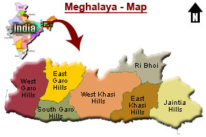
state has seven administrative districts - the East and West
Garo Hills, the East and West Khasi Hills, Jaintia Hills,
Ri-Bhoi and the South Garo Hills. Meghalaya is one of the most
picturesque and smallest states in |
 |
|
India, and
the ideal retreat for people in search of beauty and solitude.
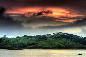
It is one of the most visited tourist states of India. It is a
happy land of breathtaking beauty, undulating hills, rolling
grasslands, cascading waterfalls, snaking rivers, terraced
slopes, hilly regions and thrilling wildlife. It covers 22,500
square kms. of rolling plateau and lies in a severe earthquake
belt. The entire town of Shillong was destroyed in the severe
earthquake in 1896. Shillong, the hill town is the capital and
the headquarter of the central district of Meghalaya. This
beautiful hill station is also known as the “Scotland of East”
for its undiluted beauty and considered as one of the most
charming places of the entire North East. Khasi, Garo and
English are the main languages which are spoken by the people
in Meghalaya. The climate of Meghalaya is moderate but humid.
Meghalaya is among the wettest places on earth. Cherrapunjee
receives annual average rainfall of 450 inches, the highest
ever recorded in Asia and the second highest in the world.
While the village of Mawsynram, holds the distinction of
seeing the heaviest yearly rains.
History of Meghalaya
Before the British came to Assam, the Khasi, Garo, and Jaintia
tribes had their own kingdoms ruled by Rajas until the British
captured them in the 19th century to build a road through the
region. The British incorporated Meghalaya into Assam in 1835.
After the India's independence in 1947, Meghalaya was given an
autonomous status within Assam. However the Meghalayans were
not complacent with the arrangement and launched a peaceful
and constitutional struggle for greater independence. The
turning point in their struggle came when Assam introduced
Assamese as the state language, a language alien to the tribes
of Meghalaya. The Centre recognized their plight and their
right for a state of their own. On 21st January 1972,
Meghalaya became a full-fledged state. Meghalaya has a
single-chamber Legislative Assembly of 60 seats. The state
sends three members to the Indian national parliament, one to
the Rajya Sabha (upper house) and two to the Lok Sabha (lower
house). |
|
|
|
Geography of Meghalaya
About one third of the state is covered by forests. The
ranges of the Garo Hills in the west, Khasi Hills, and
Jaintia Hills in the east are not especially high, with
Shillong Peak the highest point at 1,965 m. Today, there
are many caves that have unique limestone structures and
form curious stalactites and stalagmites. The Meghalaya
subtropical forests encompasses the state and its
montane forests are distinct from the lowland tropical
forests to the north and south. The forests of Meghalaya
are known for their biodiversity of mammals, birds, and
plants. Numerous rivers flow through Meghalaya, |
 |
|
|
although none
of them are navigable, due to rocky beds and strong currents.
People of Meghalaya
Meghalaya is inhabited by the three major tribes of Khasis in
the centre, Jaintias in the east and Garos tribes in the west.
Tribals constitute about 85 percent of Meghalaya's population.
About fifteen percent of the population is defined as
non-tribal which include 54,000 Bengalis and 49,000 Shaikhs.
The tribals in this State have a matrilineal and matrilocal
family system. These tribes follow the matriarchal law of
inheritance by which, custody to property and succession of
family position runs passes from the mother to the youngest
daughter. The Khasis and Jaintias belongs to the Mongolian
race, while the Garos belong to the Tibeto-Burman race. Their
cultural traits and ethnic origins remain distinctive, mainly
due to their geographical isolation. The tribal people of
Meghalaya are very short, muscular, robust, social, cheerful,
hardworking and great lovers of music and beauty. A unique
characteristic is their habit of chewing unripe betel nut with
dried tobacco, betel leaves and lime. The traditional costume
of these tribes are the 'Jainsem' and the 'Dhara', though the
younger generation has now taken to western clothes. Animism,
Hinduism, and Christianity are the main religions. There is
also a small minority of Muslims and even smaller groups of
Buddhists and Sikhs. Christian missionaries have been very
active in the area since its annexation by the British and a
majority of the tribal population have been converted to
Christianity, while non-Christians continue to worship, and
practice old cultural beliefs. |
|
|
|
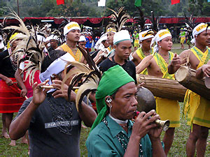
Festivals of Meghalaya
The festivals and dances of the tribes in Meghalaya vary
according to the region and tribe. These festivals are
held annually, when the ancestral spirits are appeased,
following sowing and harvesting. Ka Pomblang Nongkrem or
the Nongkrem dance, is one of the most important
festival of the Khasis. Behdiengkhlam, the most
significant festival of the Jaintias is celebrated
annually at Jowai in Jaintia Hills, during the month of
July. Wangala, is the main festival of the Garos. The
various dances are an important part of the festivals.
Shad Sukmynsiem is another important festival of the
Khasis.
More...
Places in Meghalaya
|
 |
|
|
There are
various tourist spots in Meghalaya, where nature unveils
herself in all her glory. The tourist spots can be seen in the
three different areas in Meghalaya, namely the Khasi hills,
Jaintia hills and Garo Hills. Shillong, the capital city is
located in the Khasi hills. Shillong has various beautiful
sites. Cherrapunji and Mawsynram, also known as the wettest
place of the world are located in Meghalaya. Cherrapunji is
known for the famous Nohsngithiang falls, limestone caves and
some natural stone formations. The Garo Hills form the western
part of Meghalaya, and are paradise for naturalists. The place
offers a panoramic view of the sweeping curves of Bhramhaputra
and the low lying plains. The sunset from Tura peak, the
highest point of the place at about 1400 m is a wonderful
experience.
Adventure
Activities in Meghalaya
Meghalaya, being one of the most beautifull hill states of
India, is very suitable for a lot of adventure activities like
caving, trekking, boating, camping, biking and golfing.
More...
Wildlife Sanctuaries in Meghalaya
There are two National Parks and two wildlife sanctuaries in
Meghalaya. Nobrek and Balpakam are the two National Parks and
Nongkyllem and Siju are the two wildlife sanctaries in
Meghalaya.
More...
How to reach Meghalaya
The nearest major airport is located in Guwahati, about 128
kms. Shillong is connected to Kolkata by air. The nearest
railway station is over 100 km away at Guwahati, which is well
connected to the rest of the country. The state has less than
1000 km of surfaced roads and there is only one major road
from Guwahato to Shillong. The National Highway 40 connects
New Delhi and other major cities in India to Meghalaya. |
|