|
|
Khajuraho Attractions
.............................................................................................................................................................................. |
|
Tourist
Attractions in Khajuraho
The main tourist attraction in Khajuraho are its
temples. The temples are divided into three geographical
groups namely, Western, Eastern and Southern. |
| |
|
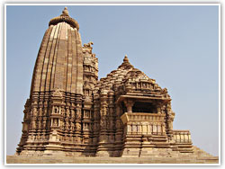
Western Group of Temples
The Western group is the best known group of
temples. In the Western Group, there are various
temples like Kandariya Mahadeo Temple, Chaunsat
Yogini Temple, Devi Jagdambe Temple, Chitragupta
Temple, Vishwanath Temple, Nandi Temple, Lakshmana
Temple, Varaha Temple, Matangeswara Temple. The
Kandariya Mahadeo temple which is the largest and
most typical Khajuraho temple belongs to this
group. This temple is about 31 metres high. |
 |
|
|
The
main temple is in an almost perfect state of
preservation. The temple has an exquisitely carved
entrance arch.
More....
Eastern Group of Temples
Hindu and Jain temples make up the eastern group, close
to Khajuraho village. The largest Jain temple,
Parsvanath, belong to this group. The image of
Parsvanath was installed in 1860. The sculptures on the
northern outer wall of this temple, make this temple the
finest temple in the eastern group. Another Jain temple
is the Ghantai Temple. On the walls of this temple the
images depicting the dreams of Mahavira's mother and a
multi-armed Jain goddess riding on the winged Garuda are
beautifully carved. Other temples are the Ghantai
Temple, Adinath Temple, Brahma, Vamana and Javari
temples.
More....
Southern Group of Temples
Five km from Khajuraho village is the Southern group.
Chaturbhuj Temple and Duladeo Temple belong to this
group of temples.
Excursion from Khajuraho |
|
|
|
Mahoba and Charkhari
Mahoba and Charkhari are about 50 km north of Khajuraho
and Chhattarpur. Mahoba overlooks the Madan Sagar lake.
Mohaba is believed to have existed under different names
in all the successive, cycle through which the world has
passed. Its name in the present ‘evil age’ (Kala-Yoga),
Mahoba is said to be derived from a great sacrifice (Mahot-Sava)
performed by its reputed founder the Chandela Raja
Chandra Varma in 800 AD. The Chandela kings, apparently,
desired two earthly things after the safe possession of
Bundelkhand: to built temples for their gods and to
bring water to the land. The Ram Kund lake marks the
place where the dynasty’s founder died and on an island
in Madan Sagar, the main lake, stands a Siva temple
dating from the 12th century. The shores of the lakes
and the islands are littered with ruined temples and
large rock figures, Buddhist and Jain sculptures left
abandoned since the Muslim invasions; a dancing Ganesh of
whitewashed granite in a mustard field here, a sun
temple dedicated to Surya the Sun god there, a vast
figure of Siva cut into the rock there.
The Chandelas obviously had a liking for water. The area
around the Khajuraho temples was flooded, and at Mahoba
they constructed four lakes by damming valley. Madan
Sagar, 5 km in circumference, was made in the 12th
century, Vijay Sagar in 11th century. The other two are
Kalyan Sagar and Kirat Sagar. Defence seems to have been
at the heart of the enterprise and the hill fort at
Charkhari is surrounded on three sides by water. The
landward approach to the fort is made though an imposing
gate, its door studded with spikes to deter elephants
from knocking it down. It leads to a courtyard and durbar
hall decorated with portraits of the Charkhari Rajas.
From there the ascent is long and gradual and this
enabled elephants and heavy guns to be taken higher.
There are canons abandoned in nearly every bastion. Also
within these walls are the temple gardens and well.
Parmadidev, the last Chandela king, was defeated by the
Chauhan emperor Prithiraj in 1182, the latter making
Delhi his strategic base. Qutb-ud-Din took the town in
1195. A number of Muslim remains survive. The tomb of
Jalhan Khan is constructed from the remains of a Saivite
temple, and a mosque whose Persian inscription indicates
it was founded in 1322 during the reign of
Ghiyas-ud-din-Tughluq. The fort fell into the hands of
Tantia Topi during the Mutiny but the local Raja Ratan
Singh remained loyal to the British and afterwards was
awarded a hereditary 11 gun salute. The view from
Charkhari across the lakes and fields is spectacular.
The ruins are of an Edwardian summer palace that was
used as a hunting lodge for large shooting parties that
terrorized the local wildfowl and, the villagers too.
|
|
|
|
Ajaigarh
Ajaigarh, about 80 km from Khajuraho and 26 km
from Kalinjar. There is an alternative, shorter
direct route from Khajuraho to Ajaigarh by back
road. Ajaigarh lies in rugged country (altitude
500 m) on a granite outcrop and crowned by a 15 m
perpendicular scarp. The excellent coffee table
book the Forts of India by Virginia Fass and
others note that although it lies deep in remote
and difficult country and is only reached by a
stiff 250 m climb, the fort repays the effort.
Like most of the forts of N India, there are
places of worship, rock carvings and sculptures to
be seen as well, some before the climb is over.
Ajaigarh was a self-contained forest hill fort,
intended to withstand long sieges and be capable
of housing the entire population of the region
within it walls. This accounts for its size. The
Chandela kings’ main defensive bases were Mahoba
and Kalinjar (both now in U.P.), but these were
complemented by |
 |
|
|
other
forts such as Ajaigarh as the kingdom expanded. In fact,
there are a large number of forts in a comparatively
small area of Kalinjar, Ajaigarh, Mahoba and Charkhari,
Garkhundar, Orchha, Datia, Samthar, Talbehat, Deogarh
and Chanderi. Many of these are Chandela forts. The
Chandelas, like other kings and emperors, donated
villages to maintain the families of soldiers who had
died in war. This was an effective means of encouraging
the continuing flow of soldiers which the system
required. Heroic virtues were instilled into a child
from birth so that any man who shirked combat was held
in contempt. Women too were taught to admire men who
fought well. A women had to be ready to die should her
husband be killed and the becoming of sati, whether
forced or voluntary became fashionable (though not with
the women concerned one suspects) throughout the region
of NW India. As the Chandela’s fortunes declined, they
lost Mahoba and Kalinjar and became confined to the area
around Ajaigarh. Much later still, when the Bundela
chief Chattrasal rose to prominence in the early 18th
century, Ajaigarh fell. On his death in 1734 the area
descended into factional conflicts until the Marathas
under the Nawab of Banda took the fort after a six week
siege in 1800. In 1808 it changed hands again, this time
falling to Lakshman Daowa. He showed no signs of
acknowledging the British presence in Bundelkhand and in
1809 the battle lines were drawn again. Under Colonel
Martindell, the British Indian army took the surrounding
hills in fierce fighting, after which they used their
artillery on the fort with devastating effect. Since
then the forests of teak and ebony have been slowly and
quietly invading the place.
Ajaigarh’s battlements show little uniformity as the
thickness of the walls never remains the same for more
than a few metres. The Muslims are accredited with using
carved pillars and door jambs from the Hindu and Jain
temples to effect repairs and fortifications. Huge
blocks of stone once formed steps for elephants on the
steep track up to the fort and now only two of the
former five gates are accessible. From Ajaigarh you can
drive directly to Kalinjar (20 km). Again its is worth
asking locally about road conditions. An alternative
route is to go to Naraini, then approach Kalinjar from
the N. This will add about 30 km to the journey. You can
always miss out Kalinjar and continue on from Ajaigarh
to Atarra Basurg.
Kalinjar
Kalinjar, 53 km south of Banda, the fort stands on the
last spur of the Vindhya hills overlooking the Gangetic
plains, a plateau (altitude 375 m) with a steep scarp on
all sides. Kalinjar is one of the most ancient sites in
Bundelkhand, referred to by the Greek Ptolemy as
Kanagora. It combines the sanctity of remote hill tops
with the defensive strength of a natural fortress.
One legend proclaims Kalinjar as the Abode of Siva, the
Lord of Destruction (Kal=death, Jar=decay). Its name,
though, is linked with the Chandela kings, and it was
one of their strongholds. In the second half of the 10th
century the independent Chandelas joined a Hindu
confederacy to repel an Afghan invasion led by Amir
Sabuktigrin. His son, Mahmud of Ghazni, the ‘idol
breakar’, made at least 17 of his almost annual plunder
raids into India from 1000-1027, in 1019 he crossed the
Yamuna river and approached Kalinjar. On this occasion
neither side could claim victory but in 1022 he returned
and took the title Lord of Kalinjar. Thereafter, it was
a depressingly familiar story. Successive Muslim
invasions weakened the forts defences and, then in 1182,
the Chandela forces were crushed by the last Chandela
king, Parmadidev, was defeated. Yet Muslim power over
the area remained unconsolidated until the rise of the
Mughals.
Like other forts of the ancient world, Kalinjar’s design
has a mystical significance, the idea being that it is
manifestation of a force greater than man’s. The only
approach is from the N but entry is through 7 gates, all
of them with barbicans, and each corresponding to one of
the 7 known planets and stations though which the soul
must pass before being absorbed into Brahma. Only some
of the names indicate Hindu significance into Brahma.
Only some of the names indicate Hindu significance. The
succession is: Alam Darwaza or Alamgir Gate after the
Mughal Emperor Aurangzeb; Ganesh Gate; Chandi Darwaza is
a double gate; Budh Budr Gate, approached by a flight of
steps; Hanuman Gate, surrounded by numerous sculptures
and inscriptions; Lal Darwaza; Bara Darwaza. At the
creat crumbling Hindu and Muslim monuments stand side by
side on the 1.5 km long plateau. Beyond the last gate is
a drop of about 3.6 m leading to Sita Sej, a stone couch
set in a chamber hewn from the rock. The inscription
over the door dates from 4th century AD. Beyond is a
passage leading to Patalganga or Underground Ganga,
which runs through Kalinjar. At the centre of the fort
is a large 90 m long tank with ghats (steps) leading
down to it. Nearby are the ruins of King Aman Singh’s
Places. Numerous stone relics are scattered about the
site; a dancing Ganes, Nandi bulls, a model temple
complete with figures like a miniature Khajuraho and a
reclining Siva. Sati pillars are scattered about the
fort, reminders of the tradition of self-immolation by
Rajput women, and there are a number of lingams and
yonis, symbols of male and female fertility.
Kalinjar was retaken from the Muslims by local chiefs
and remained Hindu until 1545 when the Afghan Sher Shah,
who dethroned the Mughal Humayun from Delhi besieged the
fort. During the heavy fighting, Sher Shah was mortally
wounded but he clung on for long enough to know that the
Hindu king Kirat Singh had ben excuted. Humayun
re-established Mughal rule in India at the end of his
life and his son Akbar took Kalinjar in 1569. Kirat
Singh married one of his daughters to a Gond Raja and
for most of her married life she waged war against Akbar,
earning for herself the reputation as heroine of
Bundelkhand.
Towards the end of Aurangzeb’s reign, the Bundela chief
Chattrasal took Kalinjar and on his death in 1732
bequeathed it to the Marathas. This was surrendered to
the British after Martindel breached the fort’s devences
in 1812. They later erected a monuments to Andrew
Wauchope, the first Commissioner of Bundelkhand. The
ancient hill of Kalinjar, standing on the last range of
the Vindhyas and overlooking the Ganges plain has long
been a place of pilgrimage and worship of Hindu sadhus,
rishis and pilgrims. It is rarely visited by other
travelers. The town below is of little interest. |
|