|
|
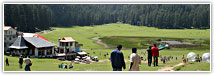
Trekking in Uttaranchal
.............................................................................................................................................................................. |
|
|
|
Trekking in Uttaranchal
The Garhwal region contains some of the finest
Himalaya mountains and is highly accessible. The
low-altitude Sivalik foothills that run across the
state are stepping stones from the plains to the
Greater Himalayas. This region has the trekking
possibilities especially during the winter.
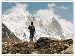
Trekking can be performed in the Inner Himalayas
for 7 to 20 days with an experienced outfitter and
modern camping equipment. The trekking can be
enjoyed in small groups. Each group is accompanied
by |
 |
|
|
an
English-speaking trained guide and experienced kitchen
staff to serve fresh meals. The trekkers do not have to
carry their backpacks more than 3 to 5 kilograms. The
rest of the equipment can be carried by porters who
accompany them. Dehradun, the capital city of
Uttaranchal is the base point for trekking.
The history behind the trekking goes
back to the beginning of the 19th century. When the
Gurkhas were expelled from Kumaon, Garhwal and Himachal
Pradesh after the 1814-15 Gurkha War, Nepal and Britain
signed a non-aggression pact which neither side
violated. However, Nepal adopted an isolation policy,
closing its doors to the rest of the world. Then, it
became a forbidden land and this stimulated a curious
fascination among the outsiders. The discovery that the
Everest is the highest mountain in the world added to
the mystique. When Nepal opened its doors again in 1950,
the first visitors were captivated by this medieval
kingdom that was seemingly unaffected by the 20th
century. The members of the first expeditions to Everest
marveled at the beauty of Nepal and widely advertised
it. Then came the trekkers and tourism gathered a
momentum. This region had been open since the British
took over in 1815 but it was abandoned by explorers in
favour of Nepal. Various early Himalayan exploration
were undertaken here. The Trisul Parvat, after it had
been climbed by Dr. Tom Longstaff in 1906 remained the
highest mountain climbed for the next 30 years. The
famous mountaineers of 1930 like Bill Tilman, Eric
Shipton and Frank Smythe marveled at the beauty of the
region. Edmund Hillary also trekked on the Mukut Parbat
in Garhwal. Later, climbers like Chris Bonington, Peter
Boardman and Mick Tasker used alpine techniques to
conquer Changabang and Dunagiri. The hill folks and
pilgrims also trekked over hills and dales due to lack
of roads and means of transportation. Adi Shankaracharya
trekked in the Garhwal Himalayas in the 8th century A.D.
and he was the pioneer who opened trekking routes in
this part of the country.
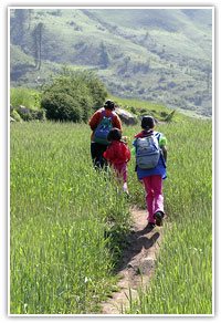
There are many trekking routes which offers some of the
most spectacular walking and scenery. There are 2
general trekking areas. Around Gangotri and Yamunotri in
Garhwal there are very good treks, some suitable for the
independent or ‘go it alone’ trekker. Nanda Devi is the
other area and this is mostly in Kumaon. The valley of
Har-ki-Doon, Pindari glacier, Kuari pass and Dodital are
the famous trekking routes. Some of the lesser known
routes are Ruinsara, Bali Pass, Buran Pass, Sahastratal
and the Rudranath and Milam Malari treks. In the
Badrinath trek, you will not be allowed to go beyond
Badrinath or north of the Dhauliganga towards the Nity
Pass as this is a sensitive border zone, usually
referred to as the Inner Line. One of the popular
trekking route is from the Kuari Pass to the Valley of
Flowers. The maximum height which can be reached in this
trek is 3658 metres. Many of these routes lead across
high-altitude meadows, passes, lakes and highest,
perennially snow-clad peaks like the Nanda Davi, Kamet,
Neelkanth, Mana. The scenic splendour of these mountains
lies partly in the fact that the forests around the big
peaks are still in marvelous condition and the local
population is unaffected by the ravages of mass tourism.
The best seasons for trekking are Februray and March at
lower altitudes for the spectacular rhododendrons, April
and May at higher altitudes, and October and November,
when temperature is low, the skies are clear and the
vegetation is green.
Trekking
Routes in Garhwal |
|
|
|
Gangotri to
Gaumukh
The best known trek here is to Gaumukh (The Cow’s
Mouth) and, if desired, beyond onto the Gangotri
Glacier. To gaumukh can easily be undertaken with
minimal equipment. From Gangotri follow the
well-defined, gradually ascending path Bhujbasa.
There is a Forest Rest House at Chirbasa, 4 km
before Bhujbasa. At Bhujbasa there is a Tourist
Bungalow and ashram where trekkers and pilgrims
can stay. It is 5 km to Gaumukh across boulder
scree and moraine and should |
 |
|
|
take
about 3 hr so it is quite feasible to go from Bhujbasa
to Gaumukh, spend some time there then return to
Bhujbasa or Chirbasa in the same day. Beyond Gaumukh
more care and camping equipment is required. The
Gangotri Glacier is situated in an amphitheatre of
6,500-7,000 m peaks which include Mana Parbat, Satopanth,
Vasuki, Bhagirathi, Kedar Dome and Shivling. Tapovan (5
km) a grassy meadow on the east bank of the Gangotri
glacier is the base camp for climbing expeditions to the
stunningly beautiful Shivling, Siva’s lingam and the
‘Matterhorn of the Himalaya’. You can either return the
same way or make a round trip by crossing over the
glacier to Nandanvan and going up to Vasuki Tal beneath
Vasuki peak. The return is via Nandanvan, the west bank
of the Gangotri glacier crossing the Raktwan Glacier to
Gaumukh.
Gangotri to Kedartal
This trek requires a tent, stove and food. It is 17 km
to Kedar Tal, a small glacial lake surrounded by Meru,
Pithwara and Bhrigupanth. Leaving Gangotri you proceed
up the gorge of the Kedar Ganga, Lord Siva’s
contribution to the Bhagirathi river, for 8 km to Bhoj
Kharak and then a further 4 km to Kedar Kharak passing
through some beautiful Himalayan Birch forest en route.
The bark from the trees was used by sages and hermits
for manuscripts. From Kedar Kharak, where you can camp,
it is laborious 5 km ascent to Kedar Tal. Besides the
peaks surrounding the lake you can also see the
Bandarpunch range. The return to Gangotri can be the
same way or over the ridge separating the Kedar Tal from
the Rudragaira Gad (river). This ridge is 700 m above
Kedar Tal and at least 5 hr should be allowed for the
crossing. Rudragaira Kharak is the base camp for the
peaks at the heads of this valley. Coming down towards
Ganotri you must cross to the opposite bank avoid the
cliffs on the W bank. Nearer Gangotri cross back to the
W Bank. This is an excellent trek with scenic variety
and spectacular views.
Gangori to Yamunotri via Dodital
This is a trek of great beauty between Kalyani and
Hanuman Chatti, a distance of 49 km. you ca do a round
trip from either end. From Uttarkashi drive to Gangotri
and get off at the Gangori (3 km) or walk it. Here take
the track to your left up to Kalyani, the recognized
starting point of the trek. From here it gets steeper as
the path climbs through forest to Agoda (5 km), a
suitable camping or halting place. The next day carry on
to Dodital, picturesquely set in a forest of pine,
deodar and oak. This is source of the Asi Ganga and is
stocked with trout. There is a Forest Rest House. Above
the lake there are fine views of Bandar Punch. To reach
Hanuman Chatti walk up to the Aineha Pass (6 km) which
also has splendid views. Then it is a 22 km walk down to
Hanuman Chatti, the roadhead for Yamunotri.
Panch Kedar Trek
Panch Kedars are the five different forms of the Hindu
God Shiva and are known as Kedarnath, Madmaheshwar,
Tungnath, Rudranath and Kalpnath. The mountainscape from
each temple is fascinating, the valley is full of rich
flora and fauna and the people are hospitable.
The Pindari Glacier Trek
This is along the southern edge of the Nanda Devi
Sanctuary and is an ‘out and back’ trek, i.e. you return
by the same route. From Bageshwar drive to Bharari. From
here you can walk 16 km along the Sarju Valley to Songh
or take another drive. From here it is just over 1 km
and 200 m to Loharkhet. Good views of the hillside
opposite and the head of the Sarju Valley. It is 11 km
from Loharkhet to Dhakuri via the Dhakuri Pass which has
a wonderful view of the south of the Nanda Devi
Sanctuary including Panwali Dhar and Maiktoli. The walk
to the pass is mostly through forest on a well graded
path. You are now in the valley of the River Pindar and
descend to the village of Khati first through
rhododendron, then mixed forests dominated by stunted
oak. Khati is a large village of over 50 households and
situated on a spur that runs down to the river, some 200
m below. From Khati follow the Pindar to Dwali (8 km)
which is at the confluence of the Pindar and the Kaphini
Rivers. Here there is a run down. If you have a tent,
camp in front. The next halt is Phurkiya (6 km). This
can be used as a base for going up to Zero Point (4,000
m) and the snout of the glacier. On either side there
are impressive peaks, including Panwali Dhar (6,683 m),
Nanda Kot (6,876 m). You return to Bharari the same way.
From Dwali, however, a side trip to the Kaphini Glacier
is worthwhile. Including this the trek can be
accomplished in a week but for comfort allow 9 days. As
there is accommodation in every place, this trek can
obviously be done with little equipment although a
sleeping bag is essential.
Kedarnath - Vasuki Tal Trek
The trek from Kedarnath to Vasuki Tal is a continuous
ascent along a goat track and it offers a panoramic view
of Chukhamba peaks. The trek starts from Gaurikund,
where one can have a refreshing bath in the hot water
sulphur springs. The trek from Gaurikund to Rambara
winds along the river Mandakini through forests and
across beautiful waterfalls. The final trek to Vasuki
Tal is downhill for 1 km. At the bottom of this, one can
see rectangular slabs of rocks.
Dodi Tal Trek
The trek to Dodi Tal starts from Uttarkashi to Sangam
Chatti and is approachable by motor. It is a gradual
climb from Sangam Chatti to Agoda through woods, fields
and villages on a mule track. The trek from Agoda to
Dodi Tal is steep and through thick forests. Dodi Tal is
situated at an elevation of 3024 meters, north of
Uttarkashi and is surrounded by dense woods of oak,
pine, deodar and rhododendrons. Dodi Tal, the crystal
clear lake is full of rare fishes and the Himalayan
Golden Trouts.
Gangotri - Kedarnath Trek
The Gangotri-Kedarnath trek is along the old pilgrim
route from Gangotri to Kedarnath. From Gangotri one has
to come down to Mala by motor. The actual trek stats
from Mala, after crossing the river Bhagirathi. The trek
is on level upto Sauri–ki–gad and from this point the
climb to Belak is gradual. From Belak to Budha Kedar, it
is downhill through dense forests full of birds and
wildlife. From Budha Kedar to Panwali, it is an uphill
climb through terraced fields and picturesque villages.
The enchanting view of the Garhwal Himalaya is very
refreshing and compensates the efforts of regular ascend
and descend. The ‘Bugyals’ (alpine meadows) on this trek
are most beautiful, specially the Kush–Kalyani and
Panwali Bugyals. |
|
|
|
Kalindikhal Trek
The Kalindikhal Trek provides a rare experience
for the most adventurous trekkers. The trek takes
one from Nandavan to Vasuki Tal after due
acclimatization. There is a gradual ascent of 10
kms. and there after, the trek negotiates
Kharapathar at a height of 5456 m. before camping
at Kalindi base. After crossing the Kalindi Pass,
one treks down to Arwa glacier and Arwatal to
Badrinath via Ghastoli with two main rivers
crossing on the way.
Valley of Flowers and Hemkund Trek
The Valley of Flowers and Hemkund trek starts from
Govindghat, on the way to Badrinath, having two
major gradients, one from Alaknanda bridge of
Govindghat to Pulana village, for 3 kms. and other
from Bhundar to Ghangharia. After trekking 3 kms.
from Ghangharia, a bifurcation point is reached.
The Valley of Flowers is |
 |
|
|
surrounded by the river Pushpavati and small streams.
The Valley is nearly 10 kms. in length and 2 kms. in
width.
Khatling - Sahasratal - Masartal Trek
The Khatling glacier is a lateral glacier, at the source
of river Bhilangana. Sahsratal and Masartal are on the
west and east of it. The valley of Bhilangana affords a
panoramic view of snow capped peaks and hanging glaciers
like Jogin group, Kirti Stambh and Meru. The whole trek
passes through thick forests and beautiful lush green
meadows. In the rainy season, the meadows burst with
splendid flowers. Trekkers will have to cross scores of
small streams on improvised log bridges on this route.
The Curzon/Nehru Trail
The Curzon/Nehru trail is a trek of unrivalled beauty.
It was the route followed by Tilman and Shipton on their
way to the Rishi Gorge, and by other mountaineers en
route to the peaks on the Indo-Tibetan border. The
crossing of the Kuari (Virgin) Pass is a fitting
conclusion to a trek that takes in three lesser passes
and five major rivers – the Pindar, Kaliganga, Nandakini,
Birehiganga and Dhauligang. The trail was named after
Lord Curzon, who was a keen trekker, and it is said that
the path was specially improved so that he could do the
trek. With independence it was renamed the Nehru Trail.
This trek begins at Gwaldam and ends at Tapoban in the
Dhauliganga Valley on the Joshimath Niti Pass road,
after crossing the Kuari Pass (3,500 m), one of the
finest vantage points in the Himalaya. From Gwaldam
proceed to Wan. Then, go over the Kanol Pass through
thick mixed forest to Sutol (10 km) in the Nadakini
valley. There is a good camp site by the river. The next
two stages follow the Nandakini downstream to Ramni (20
km) where the path leads up over the rhododendron forest
clad Ramni Pass. From here there is a good view forest
to cross the Birehiganga River by an impressive
suspension bridge, up around the horseshoe-shaped
hanging valley around Pana village, over an intervening
spur and into the forested tributary valley of the Kuai
nallah. There is no settlement here and bharal (mountain
goats) and Himalayan black bear inhabit the rich forest,
though they are rarely seen. Waterfalls tumble down over
steep crags. There is a good camp below the pass at
Dhakwani. Leave as early as possible to get the full
effect of sunrise over the peaks on the Indo-Tibetan
border. Some of the mountains seen are Kamet, Badrinath,
Dunagiri, Changabang and Nanda Devi. There is a
wonderful wooded camp site with marvelous views about
300 m below the pass. From here it is down to Tapoban
and the Joshimath – Niti road. There is a hot spring
here and a bus service to Joshimath. Allow ten days for
the trek.
Har-Ki–Dun Trek
Har-ki-Dun (God’s Valley) nestles in the north-west
corner of Garhwal near the Sutlej-Yamuna watershed. At
an elevation of 3566 meters, the Har-Ki-Dun is
surrounded by glittering peaks and dense forests. The
valley is dominated by Swargarohini. The forests are
rich in wildlife and is a paradise for bird watchers and
nature lovers. From Nowgaon, 9 km south of Barkot, take
a vehicle to the road head of Netwar at the confluence
of the Rupin and Supin streams which become the Tons.
From here is a gradual ascent over 12 km to Saur then a
further 11 km to Taluka. There is a Forest Rest house at
Osla which is 11 km from Taluka. The road from Netwar to
Osla is through dense forests of chestnuts, walnuts,
willows and chinars. The trek from Osla to Har–ki–Dun is
through terraced mountain fields, lush green grassy land
and conifer forests. There is a second Forest Rest House
in Ha-ki-Dun. This is an ideal base for exploring the
valley.
Roopkund Trek
Roopkund is situated at a height of 5029 meters in the
lap of Trisul Massif and Nanda Ghunti. This area is
usually called the ‘Mystery Lake’ since human skeletons
and remains of horses from the Paleolithic age were
found here. Thirty years ago the respected Indian
anthropologist D.N. Majumdar discovered hundreds of
skeletons around this small mountain tarn. There are two
explanations behind their presence. The first is that
they are the remains of the pilgrims on a yatra to the
base of Trisul (The Lord Siva’s Trident) who died when
bad weather closed in. Or, they may have been the
remains of the Dogra General Zorawar Singh’s army from
Jammu, which tried to invade Tibet in 1841, was beaten
off and forced to find its way back home over the
Himalaya. To this day, the mystery remains unsolved. The
lake is surrounded by rock stewn glaciers and snow clad
peaks. This is a highly varied and scenic trek which can
be undertaken by a suitably equipped party. A week is
sufficient to do this trek, nine days if you want to
take it more comfortably. Porters can usually be
obtained at Gwaldam or Debal.
The starting point of the trek is Tharali, easily
approached by motor from Rishikesh. From Tharali, drive
further to Debal, catching the jeep to Bagrigadh and
walking up to Lohajung in one long day. From Lohajung
you walk down through stunted oak forest and along the
Wan Gad (river) to the village of Wan (10 km). From Wan
it is essentially wilderness travel as you make the
ascent to Roopkund, first walking through thick forest
to Bedni Bugyal which is used a summer pasture. This has
good vies of Trisul and the Badrinath range to the
north. There are some stone shephereds huts which you
may be able to use but it is advisable to take a tent.
From Dedni it is a gradual 7 km climb along a well
defined path over the Kovali Pass to more shepherds huts
at Bakwa basa, the base for the final walk up to
Roopkund. This is not a good camp site as water is some
way off. From here, it is 2-3 hr up to Roopkund. Care
must be taken on the final steep part because the ground
can be icy. From the 4,900 m ridge approximately 50 m
above Roopkund is a magnificent view of the W face of
Trisul rising over 3,500 m from the floor of the
intervening hanging valley to the summit. Return to
Gwaldam by the ame route or via Ali Bugyal which
bypasses the village of Wan. Roopkund can also be
reached from Ghat, connected by the motorable road with
Nandprayag situated on the main highway to Badrinath.
The route passes through lush green grassy land and
conifer forests clinging on to the slopes of hills. The
trek thereafter winds its way along the Pindar river.
Then to round off this trek, one can approach Homekund
via Shall Samudra glacier and then move on to Ghat or
Nandprayag.
Treeking Routes in Kumaon
The Kumaon hills are the most picturesque hills in the
country and offers breathtakingly adventurous trekking
routes. Some of these routes are:
Pithoragarh - Tawaghat - Parwati Lake - Chhota
Kailash - Sinla Pass Trek
In this exciting trekking region of Kali, Kuti and
Dhauli rivers, one not only walks along a large portion
of the Kailash – Mansarovar route, but also gets an
exposure to the socio-cultural life of the people living
in the Chaudans, Byans and Darma valleys. Dharchula is
the base camp for trekking that takes one to Jolingkong
called Chhota Kailash and its small but beautiful lake
called Parwati Tal. The route to Sinla Pass is under a
heavy blanket of snow and from here one can constantly
see the Chhota Kailash peak.
Bageshwar - Liti - Namik Glacier Trek
In this trek one can see the snout of Namik Glacier and
the stream coming down from Anargal and meeting the main
stream after going through Jogi Udiyar the ascent of
Bhindawali and Penthang.
Munsyari - Milam Glacier Trek
Munsyari is situated on the arterial water body of the
Goriganga, which emerges from the Milan glacier of the
eastern flanks of the Nanda Devi Sanctuary, and also fed
the Kalabuland glacier and the Panchachuli from further
east. The Milam glacier snout at 3872 m. is the nodel
point for a variety of high grade routes and peaks.
Bageshwar - Saung - Sunderdhung Glacier Trek
36 kms. from Kausani, at the confluence of the rivers
Gomti and Saryu lies this religious town of Bageshwar.
Bageshwar is an important pilgrimage centre of the
Kumaon Himalayas and adorned by temples and places of
worship. Bagehwar is also the base for the popular
trekking routes of Sunderdhunga, Pindari and Kafni
Devikund, Durgakund Glaciers.
Bageshwar - Saung - Pindari Glacier Trek
The trek from Bageshwar to Pindari glacier is 3 kms.
long and ¼ km. broad. It is connected to the
south–western slopes of the outer walls of the Nanda
Devi Sanctuary.
The Nanda Devi Area
Dominating the Garhwal and Kumaon Himalaya is the Nanda
Devi Group of mountains with Nanda Devi (7,816 m), named
after the all-encompassing form of the female deity, at
its centre. Nanda Devi is the highest mountain in India
and was once the highest in the British Empire. It is an
incredibly beautiful mountain of two peaks separated by
a 4 km long ridge. The legend has it that the hand of
Nanda Devi (“She who Gives Bliss”), daughter of a local
king, was demanded in marriage by a marauding prince.
War ensued, her father was killed and she fled,
eventually finding refuge on top of the mountain now
bearing her name. She is protected by a ring of
mountains 112 km in circumference containing 12 peaks
over 6,400 m in height and in only one place is this
defensive ring lower than 5,500 m, at the Rishi Gorge,
one of the deepest in the world. It is the place of
sages. |
|