|
|
| |
|
Gujarat Tours |
|
|
|
|
| |
|
|
| |
|
|
| |
|
|
| |
|
|
| |
|
|
| |
|
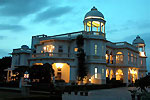
Gujarat Hotels |
|
|
 |
|
|
|
|
|
|
|
|
Gujarat Geography |
|
|
Land of Gujarat
Gujarat is situated on the west coast of India. It is
bounded in the west by the Arabian sea, in the
north-west by Pakistan, in the north by Rajasthan, in
the east by Madhya Pradesh and in the south and
south-east by Maharashtra. The state of Gujarat
occupies the northern extremity of the western
sea-board of India. It has the longest coast line of
1290 kms. The state comprises of three geographical
regions. The peninsula, traditionally known as
Saurashtra, is essentially a hilly tract sprinkled
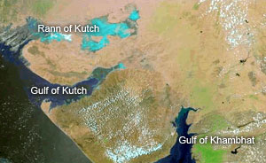
with low mountains. Kutch on the north-east is barren
and rocky and |
 |
|
|
contains the famous Rann
(desert) of Kutch, the big Rann in the north and the little
Rann in the east. The mainland extending from the Rann of
Kutch and the Aravalli Hills to the river Damanganga is on
the whole a level plain of alluvial soil.
Climate of Gujarat
The climate of Gujarat is moist in the southern districts
and dry in the northern region. The Arabian sea and the Gulf
of Cambay reduce the temperature and makes the climate more
pleasant. The year can be divided into four seasons which
are the winter season from November to February, the summer
season from March to May, the south-west monsoon season from
June to September and the intervening month of October. The
average rainfall in Gujarat varies from 33 to 152 cms. The
southern region of the state has an average rainfall ranging
from 76 to 152 cms, Dang district have the highest average
of about 190 cms. The northern district have a rainfall
ranging from 51 to 102 cms. The rainfall in the southern
highlands of Saurashtra and the Gulf of Cambay is
approximately 63 cms while the other parts of Saurashtra
have a rainfall less than 63 cms. The semi-desert area of
Kutch has a very low average rainfall. Certain areas in
Ahmedabad, Mehsana, Banaskantha, Panchmahal, Surendranagar,
Jamnagar and Kutch districts receives very less or no rains.
As the Tropic of Cancer passes through the northern border
of Gujarat, the state has an intensely hot or cold climate.
But the Arabian sea and the Gulf of Cambay in the west and
the forest covered hills in the east soften the rigors of
climatic extremes. |
|
|
|
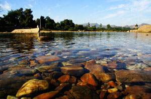
Rivers in Gujarat
The Banas in the north, originating in the Siranva
hill in Sirohi in Rajasthan, flows by the foothills of
Abu and disappears in the desert. The Saraswati takes
its birth at Koteshvar near Ambaji, flows by Siddhpur
and Patan and merges into the desert. The Sabarmati,
one of the biggest rivers of north Gujarat, originates
from the Dhebar lake in Rajasthan and flows towards
the Gulf of Cambay. The Hathmati, Vatrak, Mazam,
Meshvo, Shedhi, Khari and the other rivulets also join
it. The three virgin rivers of the north and the
Sabarmati with its tributaries are the daughters of
the Aravalli ranges, while the Mahi and |
 |
|
|
Narmada with their
families originate from Madhya Pradesh. The
Narmada, one of the biggest and holiest river along with the
only tributary, Karjan, meets the sea, about 16 kms. from
Broach. The Tapi takes its birth in the Satpura ranges near
Betwa and enters Gujarat at Kakarapar. It flows around Surat
and Rander and falls into the sea. The Mindhola, Purna,
Ambika, Vanki, Auranga, Vapi, Par, Kolak and Damanganga are
the rivers of south Gujarat, which originates in the
Sahyadri. Most of the rivers of Saurashtra and Kutch dries
up in the summer. The rivers which originate in the central
Saurashtra in the Chotila range flow to the south into the
desert of Kutch. Only the Aji, Machhu and Brahmani are
northward flowing rivers. The rivers originating in the
Girnar and Gir namely, the Ojhat, Kamb, Surekh, Somal,
Sangwada, Hirani, Kapila and Saraswati flow into the sea.
The Saraswati and Vastu are sacred rivers. Though Kutch has
many rivers, they are small and do not have much water. The
Khari flowing by Bhuj meets the desert and Magh and Tara
empty their waters in the Gulf of Cambay. The Rudramata has
been bunded for irrigation, providing the only irrigation
project in Kutch.
Mountains in Gujarat
Gujarat's mountains are rich in scenic beauty and have been
closely associated with religious and historical aspects of
the people. The northern and eastern borders are made up of
mountains which are the tails or offshoots of outside ranges
like the Aravallis, Vindhyas, Satpuras and Sahyadris.
Saurashtra contains two parallel ranges, one stretching from
east to west and the other from north-east to south-west.
The tracts of saline land of Kutch have three mountain
ranges. The Aravalli which is the most ancient mountain
range in Gujarat lies largely in Rajasthan and enters
Gujarat at Abu and zigzagging up to the Pavagadh merges into
the Vindhyas. The Taranga lies on the line from Mehsana to
Visnagar. The Arasur branch of the Aravalli goes in the
direction of Danta, Khedbrahma, Idar and Shamlaji and joins
the Vindhyas. The Satpura tail lies between the Narmada and
Tapi with Rajpipla hills. The ranges of the Sahyadri lie
across the Tapi with the highest rainfall and the densest
forest in the state. The Saler Muler and the Parner form
part of the Sahyadri range. The rocky region of Saurashtra
has only two regular mountain ranges, the northern one
having about a 357 metre peak in the Panchal region. The
Girnar which is the highest mountain in the state (1,145
metres) forms a part of the range south of the Bardo and is
about 160 km in length. The highest peak is named after Guru
Dattatreya. Garakhnath, Amba Mata, Kalika Mata are the names
of the other peaks of Girnar. The small hill beside the
Girnar, called the Jamial Shah Pir is a Muslim holy place.
The Shatrunjaya hill near Palitana is one of the five sacred
hills of Jains. The hills of Talaja, Lor and Sana are known
for their Buddhist caves.
Kutch is a saline tract with three mountain ranges. The
hills of Kutch are devoid of plant life. Among the three
main ranges in Kutch, the northern one goes by Pachham,
Khadir and Pranjal. The Kala Parvat forming a part of the
ranges lies between Kutch and Sind. The southern range
begins at Madh and goes up to Roha. |
|
|
|
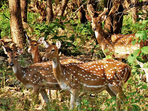
Fauna in Gujarat
Gujarat is very rich in animal life. The forest areas
of the Gir in Saurashtra, Panchmahals and Dangs have
herds of gazelles, black buck and spotted deer. The
Asiatic lion is now localised in the Gir forest, which
has also smaller mammals including langurs and blue
bulls. Gujarat having an extensive coastline,
perennial rivers and lakes and ponds are rich in a
variety of fish. Besides Asiatic lion, tiger, panther,
cheetah, wolf, jackal, fox, Civet, greyish langur,
rabbit and porcupine are also found in the forest
areas of the state. The wild ass is a distinctive
species found only in Gujarat, in the Rann of Kutch.
The thick forests of Dang, which receive maximum |
 |
|
|
rains and have abundant
greenery, are the home of beautiful birds such as Trogon,
hornbills, barbets, babblers, racket-tailed drongos and
minivets. The Saras, pea-fowls, red-wattle lapwings,
parakeets, babblers and mynas are mostly found in the
plains. The extensive coastal regions of the state give
shelter to various birds like plovers, stints, sand pipers,
curlews, lesser flamingoes, terns and gulls. During the
winter, flocks of migratory birds came to Gujarat from
faraway countries, like the pied-crested cuckoo, rosy
pelicans, white storks, Brahmany duck, demoiselle cranes,
common cranes, ducks, coots, snipes, moorhens, curlews and
stints. During monsoons, the great and the little Rann of
Kutch, serve as breeding ground for flamingoes, pelicans and
avocets. While drier areas of Kutch and north Gujarat serve
as haunt to grey partridges, larks, white-ear bulbuls, finch
larks and sand-grouses.
Forests in Gujarat
The essential criteria for the growth of forests are
suitable conditions of temperature and a heavy rainfall. In
Gujarat, high rugged areas receive a higher rainfall than
the plains. The rainfall in the state increases from the
plains to the mountains and from north to south. The forests
are therefore concentrated in the hilly parts of the state
in the south-east and in the hills of Saurashtra. The hills
of Kutch are bare because of low rainfall and the absence of
any orographic features. South, south-east and east Gujarat
are the only areas which have a considerable forest cover.
Gujarat has about 19.66 lakh hectares of land under forest.
A large part of the forest cover which is economically
exploitable is distributed in the districts of Dang,
Panchmahal, Broach, Surat, Bulsar, Junagadh, Sabarkantha and
Banaskantha. The south and south-eastern parts of the state
support the growth of tropical deciduous forest typified by
teak, Shorea Robusta for which the district of Bulsar is
well known. Moist Deciduous Forests occur in Dang and parts
of Vyara in Surat division. These forests are not evergreen
and shed their leaves during March and April. Dry deciduous
forests with teak occur in north-east Gujarat, particularly
in Sabarkantha district. The thorny forests which occur
either in Kutch or north Saurashtra and Banaskantha district
are characterized by Acacia Arabica, Acacia Leucophloea,
Capparis Ophylla, Zizyphus Mauratiana etc. There are large
stands of bamboo in South Gujarat than in the North. |
|