|
|
|
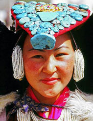
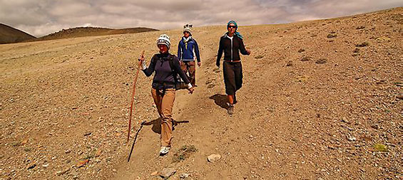
Trekking in Ladakh |
|
|
Ladakh Trekking
The Ladakhi Himalayan range of mountains provide excellent
opportunities for trekking in the wide variety of landscapes
of Himalayas. While crossing the Great Himalayan Range for
instance, one passes through all kind of landscapes getting
through the arid, alpine meadow or the forest valleys. During
the trekking route one comes across the local inhabitants of
the state living happily under the adverse conditions
prevailing in this region, meeting the local people during the
trekking makes the trekking experience in Ladakh complete. The
most popular of these treks were the 8 days Markha Valley trek
and the 11 days Lamayuru – Padum trek and the Stok-Khangri
round trek. The Valleys of Suru and Zanskar have been the
recent addition in the Tourism of Ladakh. |
|
|
 |
|
|
|
|
|
Undiscovered Areas
Some of the areas of Ladakh that were once closed to foreign
visitors on account of their sensitive strategic position or
proximity to international borders have been opened now.
Movement here is restricted to designated circuits and the
time allowed is limited. The foreign visitors are allowed to
go only in groups, accompanied by a recognized or registered
tour operator. There are different categories of entry permits
which are taken care by the Leh office. The maximum time
allowed on any circuit is seven days. Permits must be taken
from the Deputy Commissioner (head of the district
administration) in Leh, but citizens of Pakistan, Bangladesh,
Sri Lanka and Myanmar and Foreign diplomats and members of the
United Nations and other international organizations are
issued permits only with the prior approval of the Ministry of
Home Affairs, Government of India, New Delhi. Some of the new
areas are:
1. Drok-pa Circuit
2. Nubra Valley Circuit
3. Pangong Lake Circuit
4. Tso-Moriri Lake Circuit |
|
|
|
|
|
Drok-pa Circuit
CKhalatse- Domkhar - skurbuchan Achinathang - Hanudo- Diama -
Dah and return.
An expedition to this area takes the trekker to the
picturesque villages of the Drok Pa people. Down the Indus,
between Khalatse and the Shayok-Indus confluence, live Drok-pa
people, Buddhists in name, but racially and culturally
distinct from the rest of the Ladakhis. Possibly early Aryan
settlers who came in from the Gilghit area, the Drok Pas have
preserved ancient traditions that resemble Bon – chos, a pre-Buddhist
religion. Two of the five villages inhabited by them may now
be visited, Dah and Biama. The route follows the Indus down
from Khalatse, past the villages of Domkhar, Skurbuchan and
Achinathang, along a fairly good road. In the gorge of the
Indus, the sun's heat, reflected off bare rocks and cliffs, is
frequently intense. The same heat makes it possible to take
two crops every year from the fields. Fruits like apricots,
apples, walnuts and even grapes are grown. Skurbuchan, Domkhar
and Achinathang are attractive villages, with an air of modest
prosperity about them. But the special interest of this region
is less the landscape then its Drok-pa inhabitants. A
minuscule community of perhaps no more than a couple of
thousand, their features are pure Indo-Aryan, and they appear
to have preserved their racial purity down the centuries.
Their culture and religious practices are more akin to the
ancient pre-Buddhist animist religion known as Bon-chos than
to Buddhism as practised in the rest of Ladakh. One curious
feature is their abhorrence of the cow, or any of its
products. They have preserved their ancient traditions and way
of life partly through the celebration of the triennial Bono-na
festival, a celebration of the harvest, and partly through
their songs and hymns. One of these is a description of an
ibex-hunt for the ibex is specially sacred to them. Another
recalls their migration from Gilgit, an event which must have
occurred well before Gilgit came under the influence of Islam.
Their language is said to be akin to that spoken in Gilgit,
and by immigrants from Gilgit settled in Dras. Such a small
and racially and culturally homogeneous community is bound to
have much to offer scholars in the fields of ethnology and
social anthropology. |
|
|
|
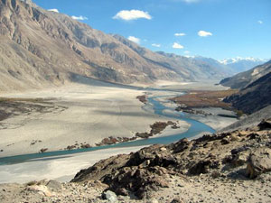
Nubra Valley
Circuit
Leh - Khardung-la - Khalsar - Tirit - Tegar - Sumur -
Panamik and return
Leh - Khardung-la - Khalsar- Deskit - Hundar and return.
Along the eastern ridge of the Karakoram range in
northern Ladakh is the Nubra Valley which comprises of
the upper Shayok and Nubra river valleys. The upper
Shayok and Nubra rivers drain the east and west sides of
the Saser Spur, the eastern most outcrop |
 |
|
|
of the Karakoram. The name
Nubra is applied to the district comprising the valley of the
Nubra river, and that of the Shayok both above and below their
confluence, where they meander in many shifting channels
over a broad sandy plain before flowing off to the northwest
to join the Indus in Baltistan. Trekking routes in this area
are rather difficult and traverses the Khardungla pass (18,380
feet) the highest motorable road in the world along the
ancient trade route from Leh to Central Asia. The line of the
road is different from that of the old pony-trail-longer and
actually higher (18,300 feet or 5,578 m). The view from the
top of the pass is amazing. The panorama view from the pass
covers the entire Indus Valley in the south, the magnificent
snow clad peaks and ridges of the Zanskar range, and to the
giants of the Saser massif. For several kilometers, on each
side of the pass, the road covered by deep snow in winter, is
rough and for the rest of the way the surface is good. At the
confluence of the two rivers there is no depth of water, but
the sandy soil is not suitable for agriculture, which is
confined to the alluvial land where side streams debouch into
the main valley. The valley floor itself is covered with dense
thickets of sea buckthorn, a thorny shrub which the villagers
use for fuel and for fencing their fields. There is now less
need for this than there was in the days of the caravan trade
with Central Asia when up to 10,000 horses a year are said to
have traversed the district. The villages are large and seem
prosperous, and have thick plantations of willow and poplar.
The altitude is little less than that of Leh, varying between
10,000 feet (3,048 m) at Hundar, and 10,600 feet (3,231 m) at
Panamik. Summer temperatures vary between 15 degree Celsius
and 28 Degree Celsius. The route passes through the attractive
villages to Deskit, the largest village in the valley. Deskit
has a regular bazaar consisting of a single line of shops, and
a Gompa. This is situated on a rocky spur above the village
with commanding views up and down the valley. From Deskit, the
tour circuit proceeds down the Shayok to Hundar, past an area
of rolling sand dunes, their contours apparently solid, yet
liable to shift with every gale. Here there is a small
population of Bactrian camels, shaggy double-humped animals,
which in the old days, were used as pack animals on the
Central Asian trade routes. During the past 50 years, they
have been bred for transport purposes in Nubra. Today visitors
can take a camel safari out into the dunes from Hundar.
The other circuit proceeds
up the Nubra river, taking in the pretty villages of Tirit,
Lukung, Tegar and Sumur. Nubra's other monastery, Samstaling
is situated on the mountainside just above Sumur. This was the
route taken by the trade caravans, and Panamik, the last
village on this circuit, was at that time a busy centre, the
last major settlement before the caravans plunged into the
mountains of the Karakoram and the Kun-Lu. Here they
invariable halted for a few days to make final preparations
for getting over the mountains, or to recuperate afterwards.
There would be no supplies, not even grazing for the animals,
for about 12 days after Panamik, so they had to carry all
their provisions for that time. The Government maintained a
granary to sell food grains for the men, and even for the
horses. But this arrangement was insufficient for the amount
of the traffic, and the local villagers made a killing,
selling grain and fodder, and letting out their fodder-fields
for the horses to graze in. Today, Panamik is a sleepy
village, its people quietly going about their work in the
fields. Though the granary is still there, converted into a
store for miscellaneous supplies, it is difficult to imagine
the village's narrow lanes congested with the bustle of the
caravan traffic. On the mountainside above, the village hot
water bubbles out of the earth in thermal springs, locally
reputed to have therapeutic qualities. And across the river,
clinging precariously to the mountain there is a sliver of
green - a few trees rooted in meager accumulations of soil
among the bare rocks surrounding the tiny Ensa Gompa.
|
|
|
|
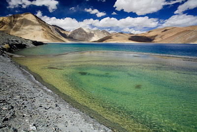
Pangong Lake
Circuit
Leh - Karu - Chang-la- Durbuk - Tangse- Luckung-
Spangmik and return.
The beautiful high
altitude of Pangong Lake in Ladakh is also another
popular destination with trekkers. This route takes the
visitor past picturesque villages of Shey and Thikse,
and turns off the Indus valley by the side-valley of
Chemrey and |
 |
|
|
Sakti. The Ladakh range is
crossed by the Chang-la (18,000 feet or 5,475 m) which despite
its great elevation is one of the easier passes, remaining
open for much of the year even in winter, apart from periods
of actual snowfall. Tangse, just beyond the foot of the pass,
has an ancient temple. The trek ends at Spangmik which is the
farthest point to which foreigners are permitted – about 7 km
along the southern bank of the lake. But the main attraction
of this circuit is the Pangong Lake, situated at 14,000 feet
(4,267 m). Its blue green waters reflect all the mountains of
the Changchenmo range. The Pangong Lake is the largest
brackish water lake in Asia or better to say that Pangong Lake
is more like an inland sea which is 150 kilometers long and
have the width of 2 to 10 km. The travel of around 160
kilometers to the Pangong Lake is really an experience. On
this picturesque journey you really realize that this is a
really isolated area. You may only come across the Army man
who are stationed there or only a few Ladakhi families who are
also glad to see and welcome you with a smile. A long narrow
basin of inland drainage, hardly six to seven kilometer at its
widest point and over 130 km long, it is bisected by the
international border between India and China. The soldiers of
Indian Armey are helpful especially when it comes to an
emergency. They also keep oxygen cylinders with them. One
should not hesitate to ask them for any help needed. For the
bird lovers this is an ideal site to take the pictures of the
Siberian crane which is black necked. The marshland of Mahe
provide them an ideal breeding ground for these migratory
birds. The boating is officially not allowed or just half a
kilometer that too with the permission of the soldiers present
there. The water of the lake are clear and cold. This lake is
also interested to the geologists and some of the researches
are going on to know more about the history of Pangong Lake.
As this lake is in very fragile ecological zone, visitors are
requested not to leave any garbage or plastic at the lake.
Spangmik, the farthest point to which foreigners are
permitted, is only some seven km along the southern shore from
the head of the lake, but it affords spectacular views of the
mountains of the Changchenmo range to the north, their
reflections shimmering in the ever-changing blues and greens
of the lake's brackish waters. Above Spangmik are the glaciers
and snowcapped peaks of the Pangong range. Spangmik and a
scattering of other tiny villages along the lake's southern
shore are the summer homes of a scanty population of Chang-pa,
the nomadic herds people of Tibet and south-east Ladakh. The
Pangong Chnag-pa cultivate sparse crops of barley and peas in
summer. It is in winter that they unfold their tents (rebo)
and take their flocks of sheep and Pashmina goats out to the
distant pastures. |
|
|
|
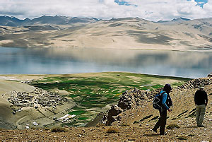
Tso-Moriri Lake
Circuit
Leh - Upshi - Debring - Puga - Tso-Moriri - Korzok and
return
Leh - Upshi - Chumathang - Mahe - Puga - Tso-Moriri - Korzok
and return.
The area traversed by
the Manali Leh road, and containing the drainage basins
of Tso-Moriri and other lakes is known as Rupshu. This
place is inhabited only by the nomadic |
 |
|
|
Chang-pa herdsmen and their
flocks of Pashmina goats, its naked hills and dusty valleys
are the setting for the spectacular Tso Moriri Lake and other
lakes in the area. One of the trek takes its way to Korzok
(4572 m) and is located just 5 km along the lake’s 23 km
length. Here, the Zanskar range is transformed into bare
rolling many-hued hills divided by open high altitude valley
scoured by dust-devils. It is a landscape unlike any other in
Ladakh or elsewhere in India. This trek goes along the
Leh-Manali road over the Taglang Pass as far as Debring, a
Chang-pa camping place. From here it strikes off east on a
rough track across the basin of the twin lakes Startsapuk-Tso
(Fresh water) and the Polokangka-la (about 16,500 feet or
5,030 m) to Sumdo in the Puga valley, near the site of old
Sulphur mines, then over a roller-coaster track to the head of
the Tso-Moriri, and on to Korzok. The alternative route,
instead of leaving the Indus at Upshi, carries on up the
river, as it snakes its way through a gorge between the Ladakh
and Zanskar ranges, to the village of Chumathang, where there
is a hot spring. At Mahe, some 17 km further, the road crosses
from the north to the south bank of the river by bridge. It
then follows the Puga stream up to join the first circuit at
Sumdo. Korzok, situated at 15,000 feet (4,572 m) with its
dozen or so houses and its Gompa appearing like a mirage among
the barren hills, is the only permanent settlement in Rupshu,
otherwise the region is inhabited only by nomadic Chang-pa
herds people. The Rupshu Chang-pa live in tents all the year
round, moving in accordance with an old-established annual
routine between the pastures and exist wherever an occasional
stream carrying snowmelt from the heights makes possible the
growth of grass, scanty indeed, but reportedly highly
nutritious. The few barley-fields at Korzok must be among the
highest cultivation in the world, but there is no guarantee
that the crop will ripen every year. Even Rupshu's bare hills
support a sparse population of wildlife, and the animal most
likely to be spotted is the Kyang, the wild ass of the Ladakh
and Tibet plateau. More plentiful are marmots (ubiquitous on
mountain slopes all over Ladakh), hares, and an unusual
tail-less rat. The lakes are breeding-grounds for numerous
species of birds. Chief among them are the bareheaded goose,
the great crested grebe, the Brahmini duck (Ruddy Sheldrake)
and the brown-headed gull found on the Tso-Moriri lake.
Trekking Tips
The easiest way to go on a trek or a safari is through a Tour
Operator or Travel Agency. They will take care of all
arrangements for camping gear, portage, provisions, etc. The
Tourist offices provide camping equipment at the Srinagar, Leh
and Kargil. Imported items like insulated ground sheets, two
man tents, sleeping bags, insulated jackets, trekking shoes
and rucksacks are available. If booked with travel agency all
your provisions and fuel from Leh or Kargil for the entire
duration of the trip will be taken care of, as nothing is
available in the outposts of this difficult area and tourists
really may not expect from the villagers for their basic
winter provisions. |
|
|
|
|
|
Ladakh Camel
Safari |
Ladakh
Cycling |
Ladakh Jeep
Safari |
Ladakh
Trekking |
Ladakh Yak
Safari |
|
|
|
|
|