|
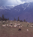
India is often said to be a continent and not a
country. It has a diverse geographical entity. Separated from
Asia by the Himalayas in the north and bordered by the seas on
other sides, it has a unity of its own which has been preserved
and nurtured in the Indian way of life. It has diverse
geographical conditions, climate, scenery and people. Here lie
some of the highest peaks, the longest plains and the wettest,
the hottest and the coldest regions in the world. In the forests
of the country exist various species of rare animals such as the
Asian lions, rhinos, sinewy tigers, sambhar, deer,
elephants and other mammals. The land mass of India falls into
the three natural regions namely the Himalayas in the north, the
Deccan Plateau in the south and the Indo-Gangetic Plain in the
middle. The north of the country is bordered by the long sweep
of the Himalayas, the highest mountain range in the world. They
separate India from China and Bhutan in the east and Nepal in
the center. To the south of the Himalayas is the vast 2,500 km
long Indo-Gangetic Plain watered by the Sutlej, the Ganga, the
Yamuna and the Brahmaputra rivers. The mighty Ganga is the
largest river of India.
|
|
|
|
|
|
|
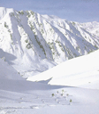
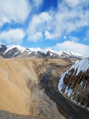
The Himalayas
are not a single mountain range but a series of ranges with
beautiful valleys. The Himalayas
stretching about 2500 kilometers from Northwest to Southeast,
dominate the entire northern borders of South Asia. They are
almost 150 and 400 kilometers wide from North to South. The Mountains that extend West from the Himalayas proper into the Hindu Kush
enclose the lowlands of Pakistan, while those in the East, have
a sudden curve southwards into Burma.
The Himalayas are of very recent origin, and they are still
being actively pushed upwards.
|
|
|
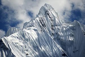
Himalayan Mountains proper,
stretching from Pakistan to the easternmost bend of the Brahmaputra in Assam, can be divided into three broad zones. On the South
are the Siwaliks, or Outer Ranges. To their North, run the parallel Middle Ranges of
Panjal and Dhauladhar, and
again to the North is the third zone, the Inner Himalaya, which has the highest peaks. The
scale of the Himalayas is incomparable and nowhere else in the world are mountain
ranges as high as the Himalayas. The speed with which the Himalayas were raised meant that there have been
huge amounts of debris washed down into the plains at their
foot.
The first ranges to begin the mountain building process were probably the
Karakoram.
The central core of the Himalayan Ranges did not begin to
rise until about 35 million years ago.
The rocks of the central core of the Himalayas were formed under the intense pressure
and are largely crystalline. Before that the present Himalayan region
rested under the sea.
The Hindu Kush: The extensions of the West end of the Himalayas run almost
South of the Pamirs through the Western borderlands of Pakistan and Afghanistan. The Hindu Kush is dominated by
Permo-Carboniferous rocks, and to the South of the Khyber Pass are the sandstone ranges and the Safed
Koh. Still further South, the borderlands of Baluchistan fall into two distinct parts. To the West, a line running due South from
Naushki, weak sandstones predominate in an extension of the
Iranian plateau. To the East of this line are successive crests of North
to South running limestone hills. These parallel ridges and valleys give
spectacular view from the air. |
|
|
|
|
|
|
|
|
Rising within 200 km of each other, the Ganga, Indus and
Brahmaputra rivers and other Small rivers have created one of
the world’s most densely populated alluvial plains. Fields have
been used since many sanctuaries for the harvesting and due to
richness of minerals in the soil farming is still possible on
these plains. Presently more than half of South Asia’s
population live on this plains whose geological origin was some
40 million years ago. As the Himalayas began their
dramatic uplift the rivers which formed on them eroded massive
quantities of rock, stone and silt. The finer material was
washed down onto the plains in near the newly forming mountain
ranges, which were themselves sinking as the mountains to the
North were rising. The trough which formed as a result of this
process was steadily filled. Today the alluvium reaches depths
of over 5,000 meters in places. The boundary between the plains
and the Himalayan ranges experiences continuous violent movement
of the earth which results into earthquakes in the West
borderlands of Pakistan, through Nepal to Assam.
Earthquaks in recent year have been observed in this area.
|
|
|
Silt and mud: The Indo-Gangetic plains are being extended and modified. The Southern part of
Bangladesh and
of West Bengal emerged from the sea in the last 5,000 years. The Ganga and the Indus
have been estimated to carry over a million tonnes of suspended material every year. Such loads have
brought great rewards for farmers. However,
they also bring vast problems, especially where large scale irrigation is undertaken. Thus, dams such as the Mangla Dam on the Jhelum River, and the Bhakra Dam
on the Sutlej
River are being rapidly filled by silt.
Underground water: The plains have some of the largest reserves of underground water in the world. These reserves have been put to use
and have made possible extensive well irrigation, especially in the Northwest plains of India, thereby contributing to the rapid agricultural changes. The plain of the Indus and the Ganga
stretch endlessly and unchangingly from East to
West. Yet there are extremely important
differences in soil and local relief which have
a great effect on agriculture
production. |
|
|
|
|
UP |
|
|
|
As recent as 50 million years ago, the land mass
on South of the line which is Karachi – Delhi – Calcutta lay in the Southern
hemisphere. Many rocks which form the peninsula and
the related structures of Sri Lanka were formed
alongside their earlier neighbours in South Africa, South America, Australia and Antarctica.
Early origins: A major part of the
Peninsula is made up of Archaean rocks, which are
3,100 million years old. They are generally
crystalline and twisted. The oldest series are the Charnockites, named after Job Charnock. Some of the most
noticeable examples are found in the Nilgiri and Palani Hills in Tamil Nadu. Other major areas of gneissic rocks are found in the Eastern Ghats,
Rajasthan, Aravalli-Delhi belt, Bihar and Orissa.
Economic minerals: Economically there are
numerous important geological series. One is the greenstone belt,
which is common in South India. Formed before 3,000 million years, these rocks contain gold, silver and copper. South Asia’s main gold mining area is at Kolar. Further North, these rocks contain some of India’s most famous
marble, and deposits of manganese. However,
these deposits are of high grade iron ore which make these geological formations significant.
Diamond: The Peninsula also has extensive areas of ancient sedimentary rocks. The oldest is the Vindhyan series which are found in the Vindhyan Mountains of
West-central India. Sandstones, limestones and shales comprise beds that are often 4000 m thick and cover over 100,000 square kilometers.
They stretch from Western Bihar to the gneissic rocks of the Aravallis and Mount Abu, and they form dramatic ridges
on the north of Narmada River. Their upper beds have two diamond baring layers from which the famous diamonds of Panna and Golconds have been mined. Of the latter, the Koh-I-noor is perhaps the most famous single diamond in the world.
Red sandstones: The red sandstones have also made a
huge contribution to Indian architecture. The Mughals
used them extensively in their city building in
northern India and Pakistan.
Coal: The Peninsula also has South Asia’s most
widespread deposits of coal. These were laid down in the Lower Gondwana Series which form three main belts in India: a linear tract along the Damodar Valley, an extensive outcrop along the upper reaches of the Mahanadi River and a series of troughs along the upper Godavari River from Nagpur to the river’s delta.
Deccan lavas: Some 60 million years ago, great cracks developed in the earth’s surface, allowing a mass of volcanic lava to
come up from the deep, covering some 500,000 square km of underlying Vindhyan sedimentaries and Archaean
rocks. The deepest lava was near the fissures themselves. The
opening up of these volcanic cracks was directly related to the separation of the Indian Peninsula from the African coastline, and the subsequent Northeast movement of the Indian plate to its present location.
|
|
|
|
|
|
|
|
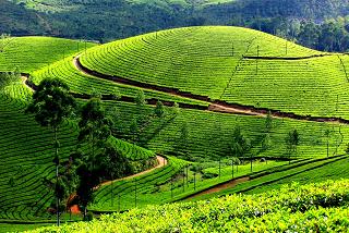
As the name
suggests, the Western Ghats run along western edge of the
Peninsula (The west coast of the states
Mahrashtra and Karnataka in the south of India). They were formed by the subsidence of the Arabian Sea as the Indian plate moved Northeast away from Africa.
Today, the Ghats are set back from the sea by a coastal plain. In the South, the Nilgiris and Palanis
are over 2,500 meters high.From the crest line of the Western Ghats, the Peninsula slopes East, interrupted on its Eastern
edge by the Eastern Ghats. Most of the peninsular rivers rise within 80 km to 100 km from the West coast, but actually flow into the Bay of Bengal. Their flat alluvial deltas have been the basis of successive peninsular kingdoms and empires from the Pallavas, Pandiyans and Cholas in the far South to the Kalingans in
Orissa.
|
|
|
|
|
|